
Summary
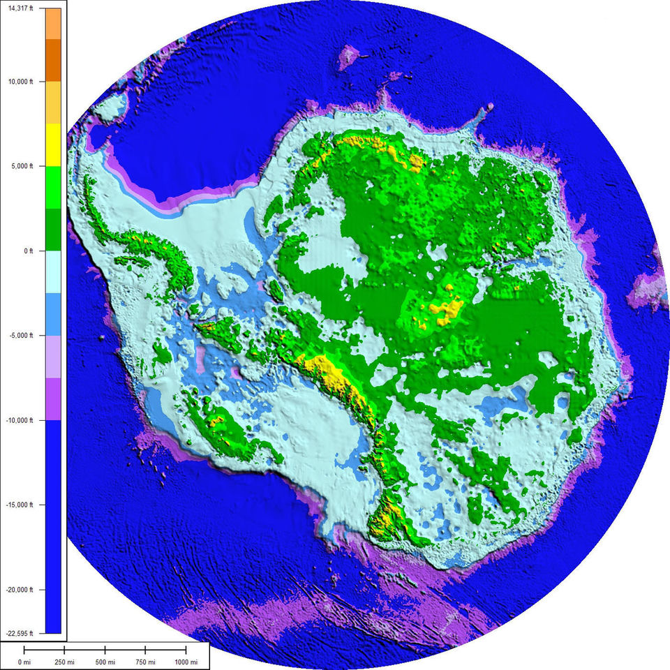
A wall of ice with worlds behind it is a claim about maps, so this sheet looks at how Antarctica is mapped today. The mapping is the work of public institutions that publish their data. Bedmap3, led by the British Antarctic Survey and released in March 2025, merges more than six decades of measurements by plane, satellite, ship and even dog sled into 82 million data points on a 500 m grid. It reveals the rock bed beneath the ice, with the tallest mountains and deepest canyons, and gives a mean ice thickness of 1,948 m including ice shelves. Its authors note that the ice sheet is thicker than first thought.
The Reference Elevation Model of Antarctica, produced by the Polar Geospatial Center from satellite stereo imagery of about 0.5 m resolution, offers surface elevation at 2 m under an open CC BY 4.0 licence. Radar surveys also revealed a subglacial lake, Lake Vostok, announced in Nature in 1996. These products show a continent of ice, rock and water whose shape is measured from space, from the air and on the ground. Nothing in these datasets points to another continent, and anyone can download the data to check.
Official version
- Official version
Bedmap3, a map of the landscape beneath Antarctica's ice led by the British Antarctic Survey, incorporates more than six decades of survey data acquired by planes, satellites, ships and even dog-drawn sleds.
- New map of the landscape beneath Antarctica's ice unveiled, Newcastle University, 13 March 2025
it incorporates more than six decades of survey data acquired by planes, satellites, ships and even dog-drawn sleds
- New map of the landscape beneath Antarctica's ice unveiled, Newcastle University, 13 March 2025
- Official version
Bedmap3 includes more than double the number of previous data points, 82 million, rendered on a 500 m grid; recent surveys filled big gaps around the South Pole, the Antarctic Peninsula and the Transantarctic Mountains.
- New map of the landscape beneath Antarctica's ice unveiled, Newcastle University, 13 March 2025
It includes more than double the number of previous data points (82 million), rendered on a 500 m grid spacing.
- New map of the landscape beneath Antarctica's ice unveiled, Newcastle University, 13 March 2025
- Official version
According to the Bedmap3 figures, the mean thickness of Antarctic ice including ice shelves is 1,948 m, and melting all of it would raise global sea level by 58 m.
- New map of the landscape beneath Antarctica's ice unveiled, Newcastle University, 13 March 2025
Mean thickness of Antarctic ice, including ice shelves: 1,948 m.
- New map of the landscape beneath Antarctica's ice unveiled, Newcastle University, 13 March 2025
- Official version
BAS mapping specialist Peter Fretwell said it has become clear that the Antarctic Ice Sheet is thicker than originally realised and holds more ice grounded on a rock bed below sea level.
- New map of the landscape beneath Antarctica's ice unveiled, Newcastle University, 13 March 2025
the Antarctic Ice Sheet is thicker than we originally realised and has a larger volume of ice that is grounded on a rock bed sitting below sea-level
- New map of the landscape beneath Antarctica's ice unveiled, Newcastle University, 13 March 2025
- Official version
The Reference Elevation Model of Antarctica (REMA), from the Polar Geospatial Center, provides 2 m resolution elevation models built from high-resolution (about 0.5 m) imagery of the Maxar satellites, released under a CC BY 4.0 licence.
- Reference Elevation Model of Antarctica (REMA), Registry of Open Data on AWS (Polar Geospatial Center)
REMA data is constructed from in-track and cross-track high-resolution (~0.5 meter) imagery acquired by the Maxar constellation of optical imaging satellites.
- Reference Elevation Model of Antarctica (REMA), Registry of Open Data on AWS (Polar Geospatial Center)
- Official version
Airborne ice-penetrating radar surveys in the early 1970s detected readings suggesting a liquid freshwater lake under the ice; the discovery of Lake Vostok was published in Nature on 20 June 1996.
- Lake Vostok, Wikipedia
they detected unusual radar readings at the site which suggested the presence of a liquid freshwater lake below the ice
- Lake Vostok, Wikipedia
British Antarctic Survey