
Summary
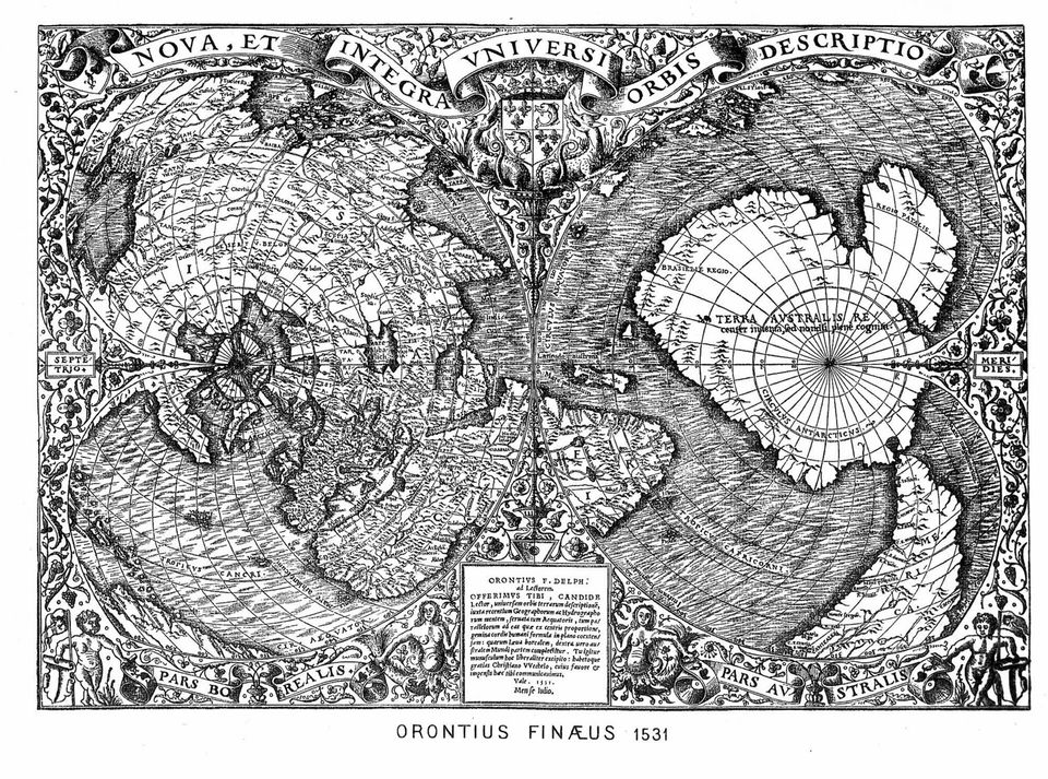
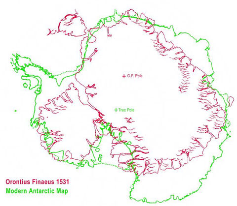
The second pillar of the theory is a printed map: the 1531 world map of Oronce Finé, in Latin Orontius Finaeus, a French mathematician appointed that year to the chair of mathematics at the Collège Royal in Paris. On it, a large southern land labelled Terra Australis sits under the tip of South America. Charles Hapgood noticed the map at the Library of Congress in 1959 and found it startling: because it was printed in 1531, it could not have been amended later. In his reading, its outline resembled modern maps of Antarctica, and it showed estuaries and inlets, suggesting great rivers, rather than the ice shelves of today. From this he concluded that Finé had used very old maps made when much of the continent was free of ice. The US Air Force squadron that Hapgood consulted is said to have gone further in 1961, reading the whole continent as mapped from ice-free sources. Zecharia Sitchin and Graham Hancock repeated the idea that the map came from pre-Ice Age maps drawn by a lost civilization, and Hancock's book places an advanced civilization on Antarctica before a pole shift around 10,450 BC. This sheet records the thesis and where it circulates; the other sheets say what the map's legend and the history of cartography show.
What the thesis says
The sources show where these claims circulate, not that they are true.
- Thesis
Hapgood saw the 1531 map in the Library of Congress in 1959 and described it as a map of what was almost certainly Antarctica.
- Piri Reis and the Hapgood Hypotheses, Aramco World (Paul F. Hoye, Paul Lunde), January 1980
a map of what was almost certainly Antarctica, done in 1531 by the French cartographer Oronce Fine
- Piri Reis and the Hapgood Hypotheses, Aramco World (Paul F. Hoye, Paul Lunde), January 1980
- Thesis
In this reading the map shows estuaries and inlets suggesting great rivers instead of today's ice shelves, so some coasts would have been free of ice when the source maps were drawn.
- Piri Reis and the Hapgood Hypotheses, Aramco World (Paul F. Hoye, Paul Lunde), January 1980
Instead there seem to be estuaries and inlets, suggesting great rivers
- Piri Reis and the Hapgood Hypotheses, Aramco World (Paul F. Hoye, Paul Lunde), January 1980
- Thesis
Charles Hapgood, Zecharia Sitchin and Graham Hancock assert that the Finé map was made from pre-Ice Age maps drawn by a lost civilization.
- Oronteus Finaeus 1531, translated by Jason Colavito, Jason Colavito (author's website), 2014
was made from pre-Ice Age maps drawn by a lost civilization
- Oronteus Finaeus 1531, translated by Jason Colavito, Jason Colavito (author's website), 2014
- Thesis
In Fingerprints of the Gods, Graham Hancock claims that an advanced civilization lived on Antarctica during the last ice age before the continent shifted south, and he dates a major pole shift to 10,450 BC.
- Fingerprints of the Gods, Wikipedia
claims that an advanced civilization lived on Antarctica during the last ice age before the continent shifted south to its current position
- Fingerprints of the Gods, Wikipedia

Unconfirmed accounts
- Unofficial, unconfirmed
A letter of 14 August 1961 attributed to a US Air Force reconnaissance squadron, reproduced online, says that the Piri Reis and Finé maps were compiled from accurate source maps, irrespective of dates.
- Piri Reis map of Antarctica, Curiosmos
we have concluded that both of these maps were compiled from accurate source maps, irrespective of dates
- Piri Reis map of Antarctica, Curiosmos
Verified facts
- Verified fact
Oronce Finé, a French mathematician, was appointed in 1531 to the chair of mathematics at the Collège Royal, the present Collège de France.
- Oronce Finé, Wikipedia
In 1531, he was appointed to the chair of mathematics at the Collège Royal
- Oronce Finé, Wikipedia
- Verified fact
On his world map Finé drew a southern land, Terra Australis, with the legend that it was recently discovered but not yet completely explored.
- Oronce Finé, Wikipedia
recently discovered but not yet completely explored
- Oronteus Finaeus 1531, translated by Jason Colavito, Jason Colavito (author's website), 2014
were meant to be Tierra del Fuego, discovered only in 1520
- Oronce Finé, Wikipedia