Summary
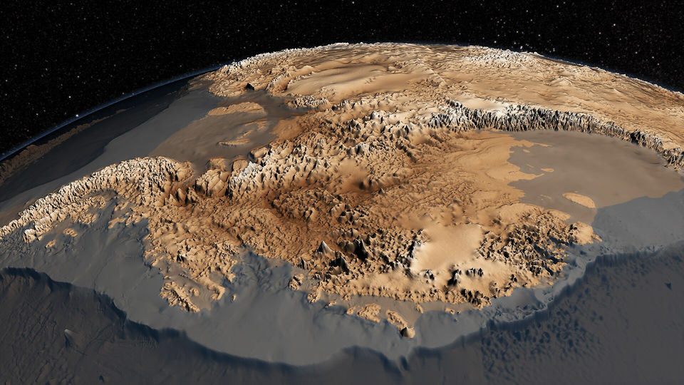
Whatever the maps are thought to show, the continent they are compared with is well documented. Antarctica covers about 14.2 million square kilometres, making it the fifth-largest continent, and most of it lies under an ice sheet with an average thickness of 1.9 kilometres. The ice is old. Glaciation of Antarctica began between 60 and 45 million years ago and escalated about 34 million years ago, when falling carbon dioxide, with a tipping point of about 600 ppm, was the main driver. Even the warm early Pliocene, three to five million years ago, left the land-based East Antarctic ice sheet largely intact. Before the ice, the continent had a relatively temperate climate and was covered in forests for much of the last 400 million years, which is a story about deep geological time and not about human memory. The first sighting of its ice shelves is dated to 1820, during a Russian expedition. Since then, surveys have measured the rock under the ice. The Bedmap2 compilation of 2013 rests on 25 million thickness measurements and shows mountain ranges, valleys and basins in much greater detail than before. This is the factual yardstick against which the two map claims of the theory are tested: a coast that lay bare at the time of any possible human mapmakers would have to be absent from every one of these records.
Verified facts
- Verified fact
Antarctica is the fifth-largest continent, about 40% larger than Europe, and most of it is covered by an ice sheet with an average thickness of 1.9 km.
- Antarctica, Wikipedia
is the fifth-largest continent, being about 40% larger than Europe
- Antarctica, Wikipedia
- Verified fact
The glaciation of Antarctica escalated about 34 million years ago, with falling carbon dioxide, around a tipping point of 600 ppm, as the primary driver.
- Antarctic ice sheet, Wikipedia
escalated during the Eocene–Oligocene extinction event about 34 million years ago
- Antarctic ice sheet, Wikipedia
- Verified fact
For much of the last 400 million years Antarctica had a relatively temperate climate and was covered in forests, despite its high latitude.
- Antarctica, Wikipedia
it was covered in forests, despite being at high latitude for most of the last 400 million years
- Antarctica, Wikipedia
- Verified fact
During the warm early Pliocene, about five to three million years ago, there was no significant decline in the land-based East Antarctic ice sheet.
- Antarctic ice sheet, Wikipedia
no significant decline in the land-based Eastern Antarctic ice sheet
- Antarctic ice sheet, Wikipedia
- Verified fact
The ice shelves of Antarctica were probably first seen in 1820, during a Russian expedition led by Fabian Gottlieb von Bellingshausen and Mikhail Lazarev.
- Antarctica, Wikipedia
The ice shelves of Antarctica were probably first seen in 1820
- Piri Reis and the Hapgood Hypotheses, Aramco World (Paul F. Hoye, Paul Lunde), January 1980
As Antarctica was not discovered until 1820
- Antarctica, Wikipedia
- Verified fact
The Bedmap2 ice thickness grid of 2013 is made from 25 million measurements, over two orders of magnitude more than the first Bedmap compilation of 2001.
- Bedmap2: improved ice bed, surface and thickness datasets for Antarctica, The Cryosphere (Fretwell et al.), 2013
the Bedmap2 ice thickness grid is made from 25 million measurements, over two orders of magnitude more than were used in Bedmap1
- Bedmap2: improved ice bed, surface and thickness datasets for Antarctica, The Cryosphere (Fretwell et al.), 2013
- Verified fact
With this data the subglacial landscape is visible in much greater detail than before, revealing the full scale of mountain ranges, valleys and basins under the ice.
- Bedmap2: improved ice bed, surface and thickness datasets for Antarctica, The Cryosphere (Fretwell et al.), 2013
the subglacial landscape is visible in much greater detail than was previously available
- Bedmap2: improved ice bed, surface and thickness datasets for Antarctica, The Cryosphere (Fretwell et al.), 2013
NASA Goddard