
Summary
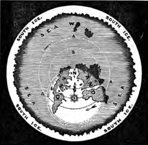
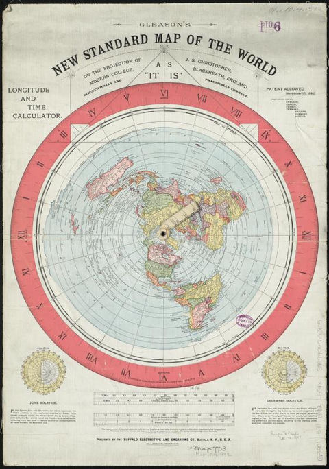
This sheet traces the founding image of the story: a flat Earth shaped like a disc, with the North Pole at its centre and Antarctica stretched around its edge as a rampart of ice. The model goes back to the English writer Samuel Rowbotham, who, under the pen name "Parallax", published Zetetic Astronomy as a short pamphlet in 1849 and as a book in 1865. In his scheme the Sun and Moon circle some 3,000 miles above the disc, and a wall of ice closes its southern rim. In 1892 Alexander Gleason published a world map centred on the North Pole and subtitled "As it is"; drawn in an ordinary azimuthal equidistant projection, it is still cited by flat-Earthers as a map of their world. From 1914, Wilbur Glenn Voliva, who ran the town of Zion, Illinois, spread the idea across the United States, southern barrier of ice included.
The image came back online after 2014 with Eric Dubay's self-published book and videos, then Mark Sargent's YouTube series Flat Earth Clues (2015). The Flat Earth Society now describes a 150-foot wall of ice in place of a South Pole, and some believers add a solid dome, the "firmament", resting on that rim. These are claims of the theory, not findings: when a TikTok video presented an encyclopedia's "dome 13,000 feet high" as proof of the firmament, fact-checkers showed it described a natural ice dome on the Antarctic ice sheet.
What the thesis says
The sources show where these claims circulate, not that they are true.
- Thesis
In Rowbotham's model the Earth is a disc centred on the North Pole and bounded along its southern edge by a wall of ice, with the Sun and Moon circling about 3,000 miles (4,800 km) above it.
- Zetetic Astronomy, Wikipedia
proposed that Earth is a flat disc centred at the North Pole and bounded along its southern edge by a wall of ice
- The Rim at the End of the World, National Center for Science Education (Glenn Branch), 12 August 2014
That the south is an immense ring, or glacial boundary, is evident from the fact
- Zetetic Astronomy, Wikipedia
- Thesis
The Flat Earth Society's current model puts humanity on a disc with the North Pole at the centre and a 150-foot (46 m) wall of ice, Antarctica, at the outer edge; believers say there is no South Pole, only this wall.
- Modern flat Earth beliefs, Wikipedia
The Flat Earth Society's most recent planet model is that humanity lives on a disc, with the North Pole at its centre and a 150-foot-high (46 m) wall of ice, Antarctica, at the outer edge.
- The New Flat Earthers (Skeptoid episode 521), Skeptoid (Brian Dunning), 31 May 2016
New Flat Earthers argue that this is because there is no south pole, just a wall of ice surrounding the circular flat Earth.
- Modern flat Earth beliefs, Wikipedia
- Thesis
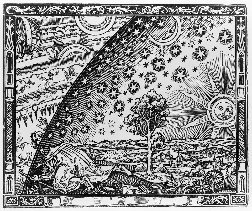
Some flat-Earthers add an indestructible dome, the "firmament", resting on the icy rim and closing the world, with the Sun, Moon and stars inside it.
- Mark Sargent (flat Earth proponent), Wikipedia
An indestructible dome is claimed to be attached to the rim, making it a closed system.
- Modern flat Earth beliefs, Wikipedia
with the sun, moon, and stars inside a dome
- Mark Sargent (flat Earth proponent), Wikipedia
- Thesis
A TikTok video presented an encyclopedia entry mentioning "a dome 13,000 feet high" near 80° South as proof of the firmament; it actually describes a natural ice dome on the Antarctic ice sheet.
- Fact Check: 1958 Encyclopedia Americana Does NOT Contain Evidence Of Firmament, Flat Earth, Lead Stories (Madison Dapcevich), 12 January 2023
with a dome 13,000 feet high at about latitude 80 degrees South, longitude 90 degrees East.
- Fact Check: 1958 Encyclopedia Americana Does NOT Contain Evidence Of Firmament, Flat Earth, Lead Stories (Madison Dapcevich), 12 January 2023

Verified facts
- Verified fact
English writer Samuel Rowbotham (1816–1884), writing as "Parallax", published Zetetic Astronomy as a 16-page pamphlet in 1849 and expanded it into a book in 1865; modern flat-Earth belief traces back to him.
- Modern flat Earth beliefs, Wikipedia
Modern flat Earth belief originated with the English writer Samuel Rowbotham (1816–1884).
- Samuel Rowbotham, Wikipedia
His work was originally published as a 16-page pamphlet (1849), and later expanded into a book (1865).
- Modern flat Earth beliefs, Wikipedia
- Verified fact
In 1892 Alexander Gleason published a world map in azimuthal equidistant projection centred on the North Pole, subtitled "As it is"; flat-Earthers often cite it as a map of the flat Earth.
- Behold – A Flat Earth Map (Gleason's New Standard Map of the World), Brilliant Maps
It was created by Alexander Gleason and first published in 1892.
- The Flat Earth Map, Maps Mania (blog), December 2025
reflecting Gleason's belief that the map showed a world that was flat - and not round.
- Behold – A Flat Earth Map (Gleason's New Standard Map of the World), Brilliant Maps
- Verified fact
From 1914 Wilbur Glenn Voliva, who ran the town of Zion, Illinois, promoted the flat Earth nationwide, offered $5,000 to anyone who could disprove it and owned the radio station WCBD (1923); he too believed in a southern barrier of ice.
- Wilbur Glenn Voliva, Wikipedia
From 1914, Voliva gained nationwide notoriety by his vigorous advocacy of the flat Earth doctrine.
- The Rim at the End of the World, National Center for Science Education (Glenn Branch), 12 August 2014
similarly believed in a southern barrier of ice, as revealed by a map used in the schools of Voliva’s home of Zion, Illinois
- Wilbur Glenn Voliva, Wikipedia
- Verified fact
The ice wall returned online after 2014: Eric Dubay self-published The Flat Earth Conspiracy in November 2014 and then the "200 Proofs" video, and in 2015 Mark Sargent launched the YouTube series Flat Earth Clues (two million views), describing a disc with a giant wall of ice around it.
- Mark Sargent (flat Earth proponent), Wikipedia
In 2015, Sargent released a series of videos he created on YouTube called Flat Earth Clues
- Modern flat Earth beliefs, Wikipedia
In 2016, Eric Dubay, of the "200 Proofs" video,
- The New Flat Earthers (Skeptoid episode 521), Skeptoid (Brian Dunning), 31 May 2016
Eric Dubay is a conspiracy theorist who, in November 2014, self-published a book on Lulu.com titled
- Mark Sargent (flat Earth proponent), Wikipedia